Hoosac Range
Ridgeline trail along the Berkshires’ northeastern wall with cool rock cliffs and several dramatic vistas: prepare for the sublime!
Highlights
- North Adams and Florida, MA
- 1.6 to 6 miles of trails
- Difficulty: Easy to difficult
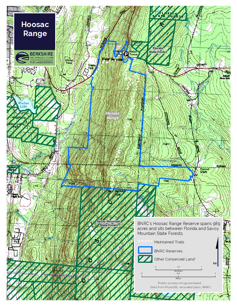
- Size: 989 acres
- Especially good in: Fall
- Special features: Blueberries at Sunset Rock, awesome spring snowshoeing, and migratory raptors in fall.
This land, and all of the present-day Berkshires, are the ancestral homeland of the Mohican people, who were forcibly displaced to Wisconsin by European colonization. These lands continue to be of great significance to the Stockbridge-Munsee Mohican Nation today. To learn more, visit mohican.com.
Directions & Parking
GPS
- Trailhead Parking: Goolgle Maps | 42.6965, -73.0648
From North Adams
Take Route 2 east. Past the hairpin, on the top of the hill, the parking and trailhead will be on your right.
From Pittsfield
Take Route 8 North, at the Cumberland Farms in North Adams, take a right onto 8A. Then take a right, heading east on Route 2. The trailhead parking is on the right at the top of the hill, immediately after the Wigwam Cabins.
Trail Description
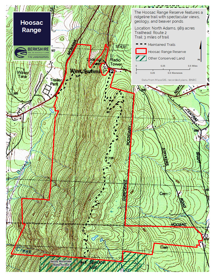
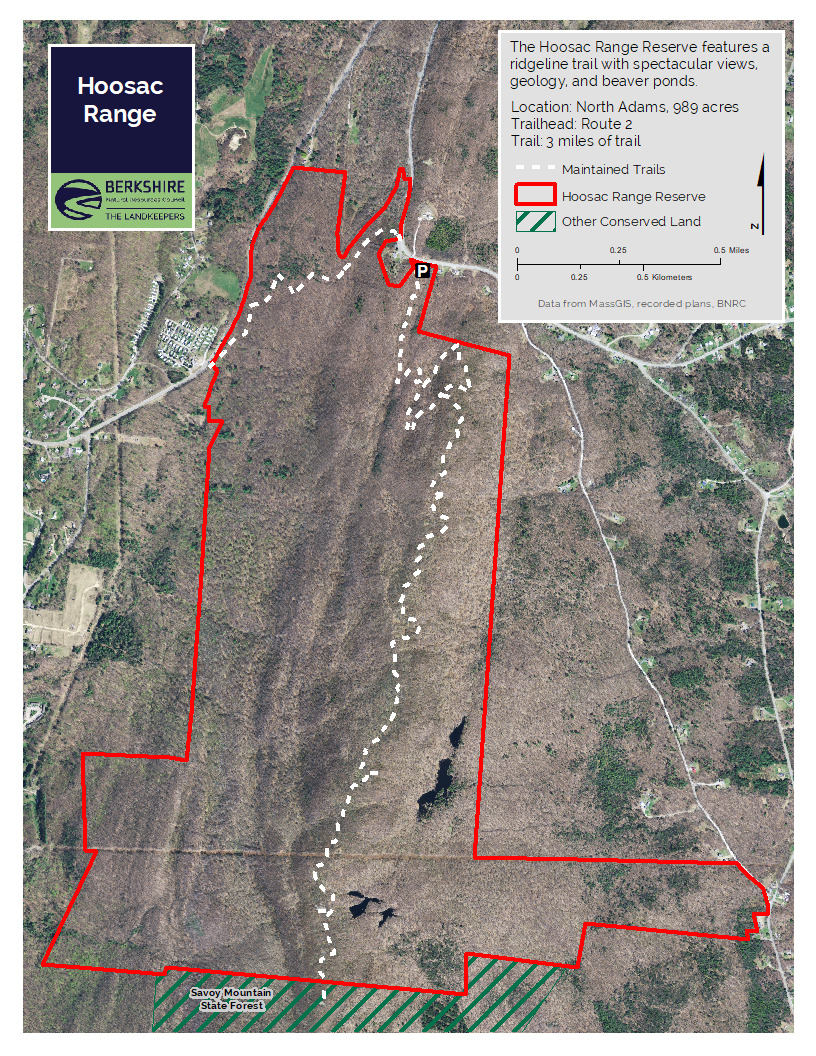
- Sunset Rock: 1.6 miles roundtrip, 1.25 hours, easy
- Spruce Hill: 6 miles roundtrip, 4 hours, difficult
Spruce Hill
From the trailhead, hike three miles along a ridgeline to Spruce Hill, with its 180-degree views including Mount Greylock to the west. Hikers can return or descend to trailheads in Savoy Mountain State Forest by the Busby or continue on the Mohican Mohawk Trail. An out-and-back trip on the Hoosac Range Trail is about six miles and takes three to four hours. Far beneath the trail is the Hoosac Tunnel, a rail connection between Northern Berkshire and Boston that opened in 1876.
Sunset Rock
The shorter inner-loop hike to Sunset Rock provides views to the west and north, overlooking North Adams. A round trip is 1.6 miles.
About the Reserve
A three-mile long ridge trail along the Berkshires’ northeastern wall, Hoosac Range includes several dramatic vistas, including the one to the west at the trail’s Spruce Hill destination. A much shorter hike, 1.6 miles roundtrip, leads to Sunset Rock, which also has spectacular views to the west.
The 944 acres of the Hoosac Range property connect with the Massachusetts Department of Conservation and Recreation’s 11,118-acre Savoy Mountain State Forest. The sheer size of the protected area provides abundant habitat for a range of wildlife, from bears to beavers.
Designed by Peter Jensen, the Hoosac Range trails take hikers past several outcroppings of the range’s characteristic Hoosac schist, a sedimentary rock that first began forming under the warm oceans of the Southern Hemisphere 550 million years ago, before traveling north via plate tectonics. The schist remained after the softer marble and limestone that surrounded it eroded under the constant melt-flow of glaciers.
The Hoosac Range Trail is also part of the Mohican Mohawk Trail, envisioned as a 100-mile foot trail from the Hudson River, over the intervening mountain ranges, and back down to the Connecticut River. Heading east from here, the Mohican Mohawk Trail travels to Savoy Mountain State Forest, and then on to Mohawk Trail State Forest, where it traverses an original section of the historic native American path between the two great rivers.
History
Landscape Background
Native Americans first used the Mohawk Trail (now Route 2) to travel through the northern Berkshires between the Hudson and Connecticut rivers. Today a drive east 4.5 miles on Route 2 from North Adams through the “Hairpin Turn” to the top of the ridge brings you to a unique place known as “the Western Summit.” Just beyond the Wigwam cabins on the same side of the road is a large parking area where a BNRC welcome sign and an information kiosk mark the entrance to the trail.
With unparalleled views from the top of Route 2, entrepreneurs once made this area a popular tourist stop, with a gift shop and cabins. A tall viewing tower meant visitors could climb up to survey New York, Vermont, Mount Greylock, the Taconics, and the surrounding state forests. The Wigwam Western Summit is now open and offers a coffee and gift shop and hot dog and soup bar.
Purchase and Preservation
This ridge defines the eastern horizon in the north Berkshires and securing it required patience, creativity, negotiating skills, and luck, in the form of landowners willing to sell. Following up on a tip in 2007 from a local citizen that Adelphia Cable was auctioning off its ridgeline parcel, BNRC stepped in and purchased those 193 acres. Over the next two years, five more owners, including the proprietors of the Wigwam, agreed to sell their land. The transactions secured an unbroken 2-mile-long tract along the ridge.
The Massachusetts Department of Conservation & Recreation, which owns the Savoy Mountain State Forest, purchased a conservation restriction over the entirety. The CR ensured a double layer of protection for the mountain and helped to eliminate the red ink from BNRC’s $1.1 million spending spree.
With the property secured, BNRC tackled the job of designing, funding, and building a trail along the spine of the ridge that would capture the most fascinating landscape features while appealing to experienced and novice hikers alike.
At a cost of about $145,000, a skilled crew of trail builders working under the guidance of Peter Jensen & Associates, built the three-mile trail from the parking lot to Spruce Hill. This trail comprises a section of the proposed Mohican-Mohawk Trail, a 100-mile path replicating the Native American route.
Natural History
The trail takes hikers past a tree whose head-level burl recalls nothing so much as the “Star Wars” character Yoda. Another tree’s hollowed-out interior lets you look back at hikers following you. All along the ridge, many trees have been bent into twisted shapes by the constant stress of wind, ice and snow. Wildlife include bears, bobcats and, especially at Spruce Hill, raptors in migration. A beech on the trail shows bear claw marks— evidence of climbing the tree for beech nuts.
Along the trail are spring ephemerals, including hepatica. Hobblebush lines much of the trail. The trail passes moss- and lichen-covered cliffs where you traverse the rock face on carefully placed stone steps. Depending on the season, the cliffs may drip with water or ice.